Day 4 on Route 66: Pushing through Oklahoma


View Larger Map

This is going to be a long post! Today was a big day on my trip: I passed through Oklahoma, which is the most important Route 66 state in my opinion; I also drove through two other states, Kansas and Missouri, making it three—count ’em, three!—states I passed through today; I drove on possibly two of the best sections of Route 66 (details coming up!); and finally, I made up for time lost in the urban obstacle course of Chicago.

First, a note on alignments. I have been speaking of Route 66 as if it has been in the same place on the map since its origination. That this is not true should be clear from my earlier example from Illinois, where I showed the older, cordoned-off, pavement running alongside the Route 66 pavement I was actually driving on. That would have resulted from realigning the road along a different route, in this case, a route exactly parallel to the original. Many, many realignments have happened over the thousands of miles of Route 66 over its many decades of operation. In many cases, more than one alignment runs between two points, and the traveler needs to choose between them (unless he is one of those who devote their lives to documenting and experiencing every single inch of Route 66 alignment; the guide books I’m using are written by some of these people).

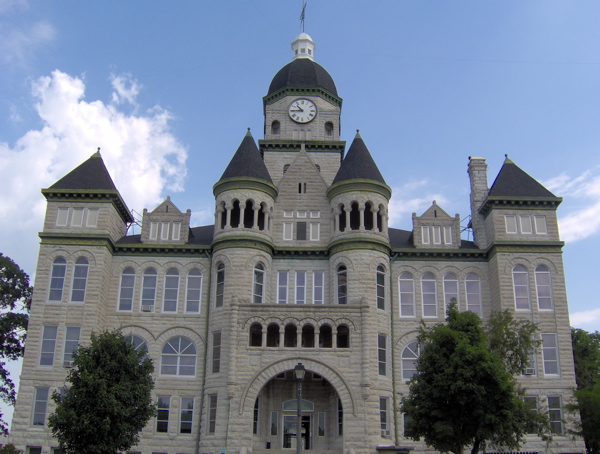
I had stayed for the night in Springfield, Missouri, which is towards the end of Missouri’s share of Route 66. I started earlier than usual, because my intention was to push through Oklahoma today. The morning was a very pleasant time to be driving on rural roads. I headed out on Route 66 from Springfield, passing by a number of quiet towns—Halltown, Heatonville, Albatross, Phelps, Rescue, Plew, Avilla, Carthage—before reaching the big town of Joplin. These small towns, with the exception of Carthage, have acquired a ghostly feel after a realignment many years ago. Carthage was home to rich people who made their money in mining. Here’s the stately courthouse:
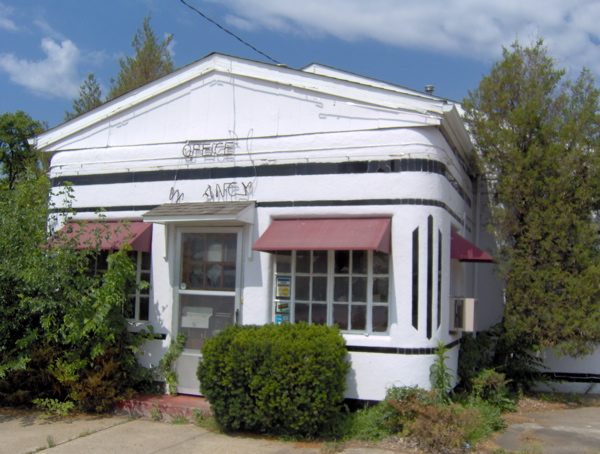
I also checked out the historic Boots Motel in Carthage, which was established in 1939, and was very modern for its time, with a radio, air conditioner and other amenities in every room. This property lies in thorough disrepair now:
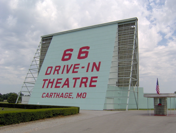
Also in Carthage is a recently restored Route 66 Drive-In movie theatre.
From Joplin, I started noticing a lot of Mexican restaurants, reflecting the changing demographics in my journey. After Joplin, Route 66 leaves Missouri and enters Kansas, where it stays for the very short distance of 13 miles. This part of Kansas, and the part of Oklahoma that 66 enters after it, is lead- and zinc-mining country. I stopped at the ancient Eisler Brothers Store (dating back to around 1925).

After leaving Kansas, I entered Oklahoma. Oklahoma has a central significance to Route 66. The man who was the force behind the conception and creation of Route 66, Cy Avery, was from Tulsa, Oklahoma, and he made sure the highway passed through his state and hometown, even though that is not the most direct route. But there’s more. Oklahoma was also the state that suffered the most during the dust storms I mentioned earlier, and the migrants in John Steinbeck’s Grapes of Wrath were Oklahomans. Finally, the chap who won the foot race I mentioned earlier was from Oklahoma. That foot race was a big, early step in putting Route 66 in people’s minds.

Oklahoma used to be Indian Territory until its statehood in 1907. In Oklahoma, I saw a lot of shops describing themselves as Indian trading posts, which is probably what they used to be in the old days (before credit cards). With Oklahoma I entered the Great American West. I’m hoping I will find the time to visit Monument Valley from Flagstaff, Arizona. From the pictures I’ve seen, Monument Valley is my favorite symbol of the Great American West.

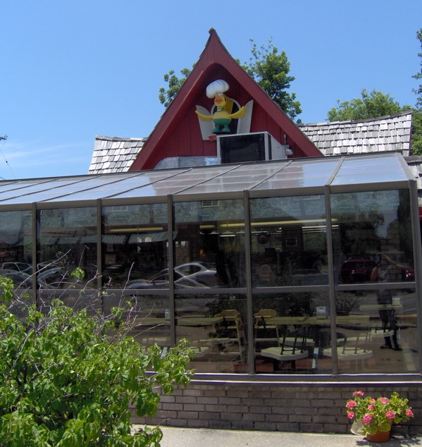
In Oklahoma, my first stop was Miami, where I had lunch at Waylan’s Ku-Ku, an old Route 66 establishment. The bird on top of the building was at one time a working cuckoo clock.
I thought lunch was delicious, but I was in for a much bigger treat soon after. This part of Oklahoma has preserved a few alignments of very, very old pavement, dating back to 1922, even before it was called Route 66. This pavement is just nine feet wide, and makes a somewhat rough and dusty drive today. I sought this out and drove on this historic section of Oklahoma road:
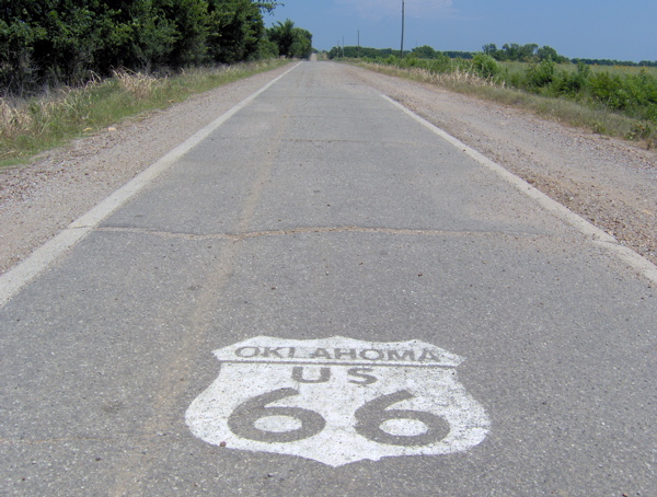
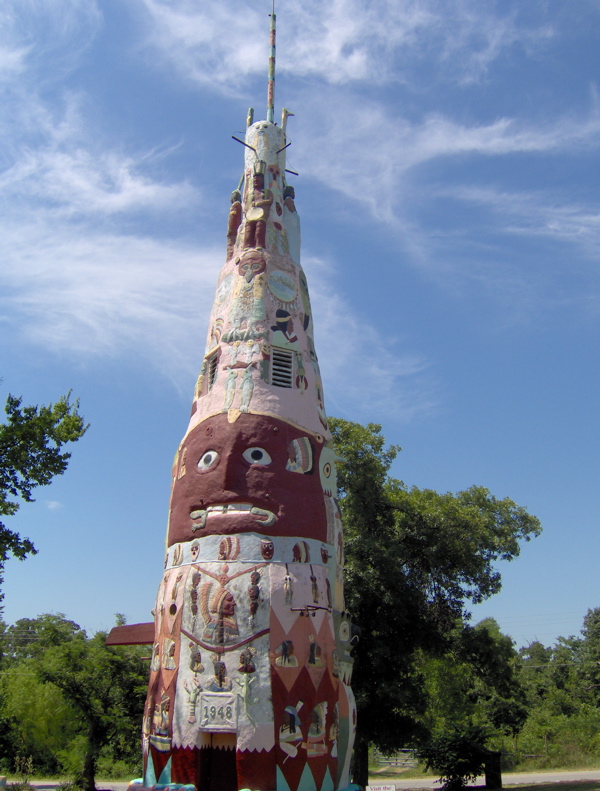
As you can see, there is only one lane, and there isn’t room for two vehicles side-by-side on this road. After this section ended, Route 66 acquired a very modern feel, because Oklahoma has turned it into a major four-lane transport corridor for a good distance. This is not much fun, but I stuck with it, passing through Vinita, Chelsea, Bushyhead, Foyil, Claremore, Verdigris and Catoosa.. In the old days, a drive on Route 66 used to be full of quirky, eccentric roadside attractions such as totem poles, reptile pits and other oddities and curiosities. Here’s a famous 90-foot totem pole that has been preserved near Foyil:
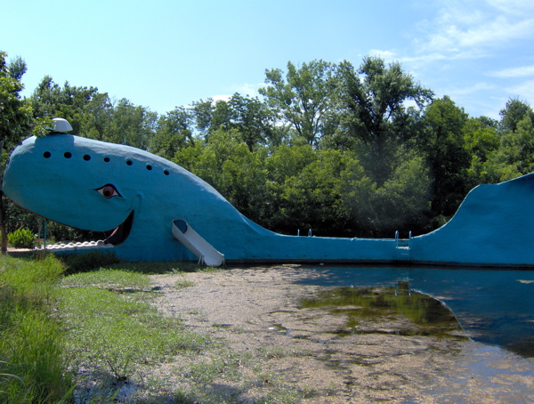
Another very famous but odd Route 66 attraction used to be the blue whale in Catoosa, popular with children. This was obviously before theme parks were invented. The whale has recently been re-opened, but not for use as diving board anymore:
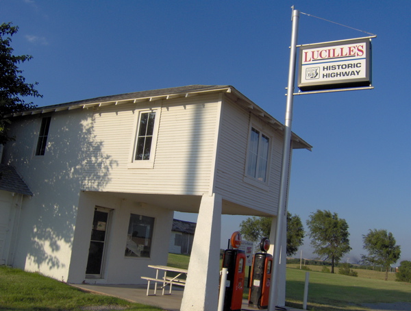
At Catoosa, I hopped on the interstate to speed my journey and got off at El Reno. Between El Reno and Hydro, I experienced the second highway treat of the day: miles and miles of pristine-condition 1933 concrete as it was laid down then, through quiet farmlands, and with the distinctive thud-thud noise signature caused by the old concrete sections. This was a super treat, which I enjoyed among the elongating shadows of the evening. Amazingly, I did not see a single soul in the fields or in the houses. At Hydro, I came to another Route 66 classic, Lucille’s gas station, dating back to 1941, but now shuttered. Lucille was Lucille Hamon, and she was known as the Mother of the Mother Road.
Near Hydro, and still in Oklahoma, is Clinton, where I’m staying for the night. Oklahoma is almost done, and tomorrow I will be in Texas. I’m glad I put in the effort to push through Oklahoma today, so I can again take it easy from tomorrow.
Day 3 on Route 66: Cutting through Missouri, St. Louis to Springfield


View Larger Map

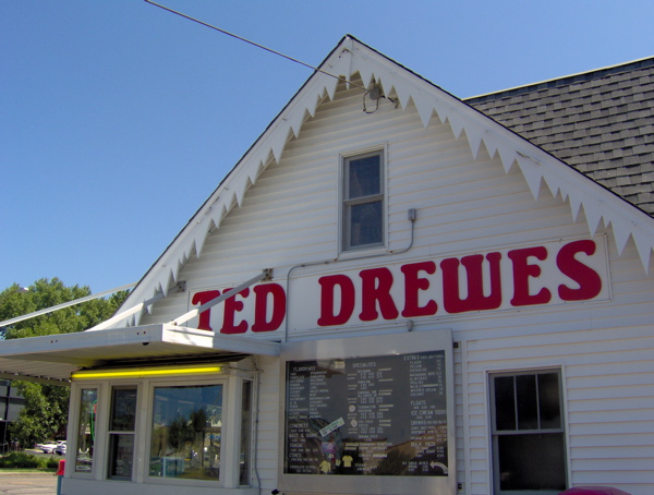
My day started where last night had ended, at St. Louis, Missouri. I spent the day following the diagonal path of Route 66 through this state. My Route 66 map for Missouri said “Routings through St. Louis are numerous and complex, and even after a process of elimination, choices must be made.” This opening line was daunting enough that I made the choice to take the freeway out of St. Louis, considering my tight schedule. But I did make one traditional Route 66 stop in St. Louis: Ted Drewes’ Frozen Custard. This Route 66 icon has been in operation since 1941 and is still very popular, as I could tell from the crowd on a Monday morning (not visible in the picture).

As I drove on the freeway tracking Route 66, I noticed that the north-south 55 interstate of the last two days had handed the baton to the east-west 44 in St. Louis. I also noticed that the last two days’ flat driving over the Illinois prairie had shifted to hilly ascents and descents. In the terrain map below, notice the change in terrain across the Illinois-Missouri border. This border is defined by the Mississippi River, which separates the Ozark Highlands of Missouri from the plains of Illinois.


View Larger Map

I left the freeway at Stanton, gateway to the famous Meramec Caverns, another Route 66 staple for travelers in the 1930s. These are limestone caves that you can tour. They were aggressively marketed all over the Midwest by having the sides of barns painted with advertisements for this attraction, not just along Route 66, but other highways as well. Their clever marketer advertised the caverns as the former hideout of the outlaw Jesse James, despite the lack of strong supporting evidence. Soon, people far and wide had heard of the Meramec Caverns, and the caves became a veritable pilgrimage for (the gullible?) Route 66 travelers.

At Stanton, I got on to Route 66, and passed through numerous small towns again: Stanton, Sullivan, Bourbon, Cuba, Fanning, St. James, Doolittle, Clemetine, Hooker. Rolla was the one big town I passed through. Driving this section was like being on a gentle roller coaster ride, because the old road followed the ups and downs of the terrain, whereas the newer high-speed interstate system was built to grade out much of this variation for safer driving at high speeds. I could see this difference clearly as I compared my road with the interstate I was driving next to.

I sought out the “Devil’s Elbow” and drove on it. This is a now-bypassed section of Route 66 that is a bridge over a sharp bend in the river below. It was bypassed in the war years when transporting big military trucks through the sharp turn caused difficulties.

I took the freeway to Springfield, where I noticed a sign for a historical homestead site (the Nathan Boone Homestead). I took a detour to check out this potentially fascinating exhibit, but as I suspected, it was too late in the evening to visit it. It features a log cabin built in the late 1870s.

It was pretty late in the evening; the sun and elusiveness of Route 66 had worn me out. I couldn’t make it to Joplin, the last stop in Missouri, as I had planned, and took respite in the serendipitous discovery of a chain hotel while trying to sniff out Route 66 at Springfield.

Missouri hasn’t done nearly as good a job as Illinois with the road markings for Route 66, and today was rather hit-and-miss. If this keeps up, I’ll have to seek out just the easiest sections of Route 66 in each state. Tomorrow is big, because I will be driving in three states: Missouri, Kansas and Oklahoma.

Day 2 on Route 66: Out of Illinois and into Missouri


View Larger Map

I started the day fresh and well rested, and had a good experience. Thanks to the Historic Route 66 signs placed by the state of Illinois, staying on track was achievable without a navigator. I started at Joliet and drove through a number of small towns: Wilmington, Braidwood, Gardner, Dwight, Odell, Pontiac, Chenoa, Lexington, Towanda, Normal, Bloomington, Divernon, Litchfield. As I drove through these little town centers, I got a palpable sense of how different life must have been in the Route 66 heyday, and how businesses must have folded up after the interstate came along (except at Litchfield, which seems to be doing pretty well, and Bloomington, which is a big town). This is not like freeway driving at all.

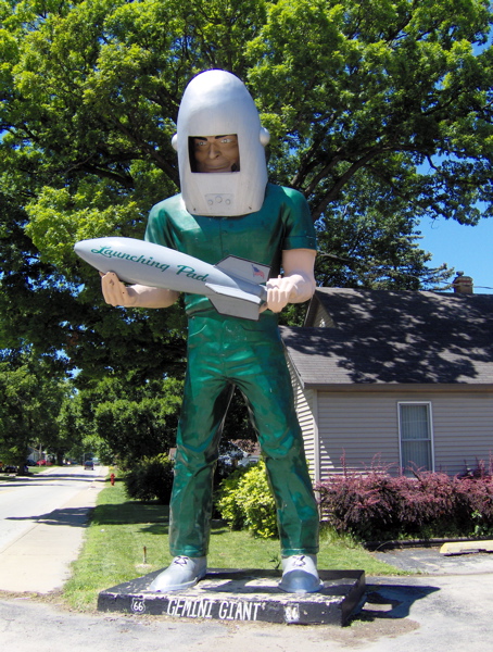
I drove through Wilmington, which I knew from last night. I passed the Launching Pad Drive-In and the Gemini Giant in daylight, and took a much better picture than yesterday’s:

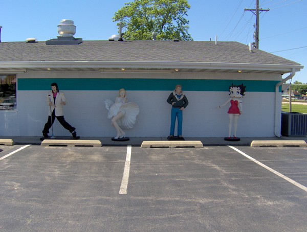
Further up the road is the since-1956 Polk-A-Dot Drive-In, where I spotted some celebrities:

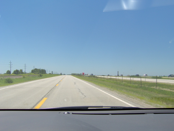
I noticed I was driving parallel to and in sight of the railroad tracks and the freeway for a good part. This reflects the evolution of the transportation lines: paved roads were built parallel to the rail tracks, and the freeway was built parallel to the older generation road. In this picture, I am on Route 66, the rail tracks are to my left, and interstate highway 55 is to my right:

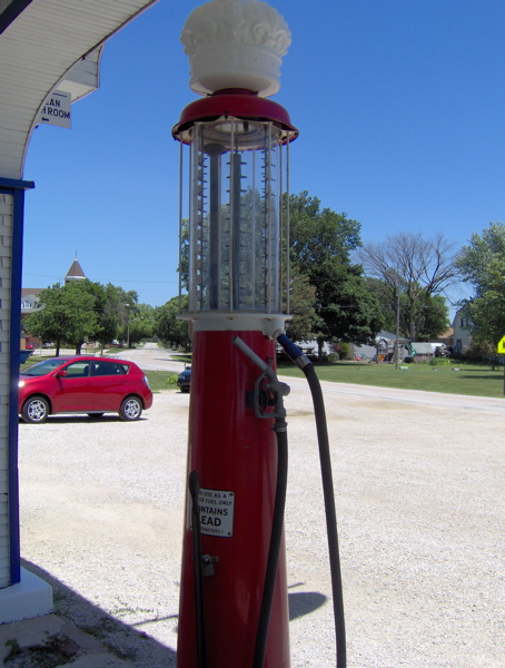
At Odell, I came across a preserved gas station dating back to 1932. It is no longer operational. This is how they filled gas back then:

The transparent container on top has gallon markings. Fuel was measured out in it, then transferred to the car. I spoke to the storekeeper about last night’s thunderstorm, and he said he too was impressed by the light show. He said he hadn’t seen lightning like that in years, and he’s a local.

I followed Route 66 until Bloomington. The original pavement seemed to be running alongside me, cordoned off to motor vehicles. Here it is, the Mother Road itself:

In Lexington, there’s a section of the original pavement like the one above that you can stroll on.

Starting at Bloomington, Route 66 starts overlapping with the freeway quite a bit, and staying on it feels like a lot of effort. I got on the freeway and headed for the Cozy Dog Drive-In at Springfield, started by the inventor of the corn dog. I thought I could smell those hot dogs from 50 miles away, but when I got there, I discovered they are closed on Sundays. Oh well. Back on the freeway and back off at Divernon to drive on 66, with the intention of eating at the Ariston Cafe, perhaps the oldest restaurant on Route 66. Route 66 was closed south of Divernon, but I got to Litchfield and the Ariston Cafe via the freeway.

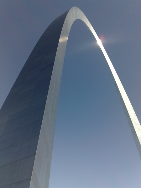
It was late afternoon, and I’d had my fill of navigating Route 66 for the (sunny) day. I made a beeline for St. Louis (the next big city on Route 66), leaving the flat prairie of Illinois behind and crossing the Mississippi River. I didn’t know if I would stop at St. Louis or press on after a quick look at the Gateway Arch. But when I did get to the Arch, I was so impressed by its engineering and significance that I checked into a nearby hotel for the night and spent the rest of the evening touring the Arch.

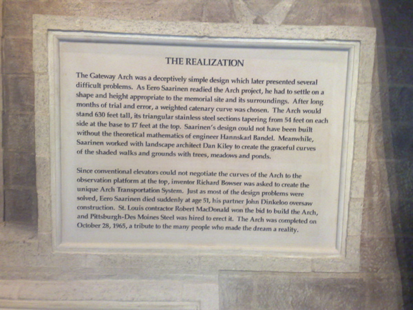
The Gateway Arch is a staggering 630 feet tall. It is a graceful and majestic structure, conceived by the mind of a great architect and designed and forged by skilled engineers and workers. It is in the shape of a (weighted) catenary; the narrowing of the cross-section towards the top and the angled sides lend it great beauty.

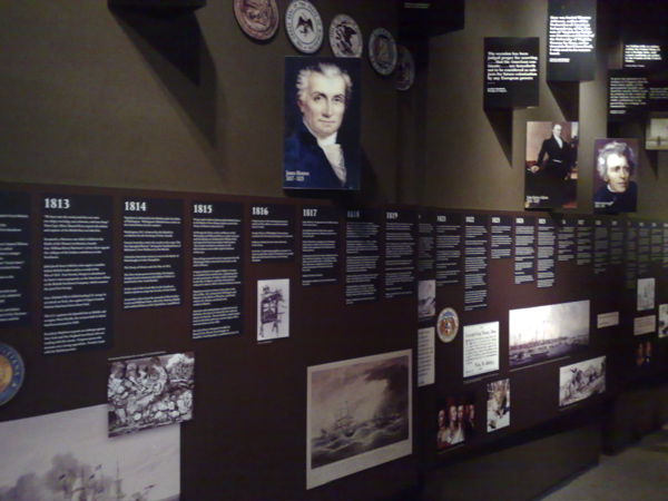
The Arch is a monument to the western expansion of the United States, and to the role that St. Louis played in that expansion. Given the history of Route 66 and the spirit of my journey, the Arch seemed to be an important and relevant symbol, and its symbolism, beauty and craftsmanship drew me to it. Everything about its exterior seemed to suggest that there was no access to its interior, far less its apex. However, I noticed a row of windows at the apex, and then a whole subterranean complex housing a museum and serving as a launchpad for a ride to the top of the arch from within. The museum is about the westward expansion of the US, and has a judicious selection of material that anyone could absorb in a typical visit:

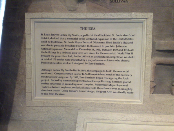
The ride to the top was intriguing. Because of the curve of the Arch, regular elevators won’t do, and special trams have been installed to carry 40 passengers at a time to the top. The tram ride is claustrophobic, but very curious in its movement. It does not move like a train or elevator, but seems to move in all kinds of directions during its journey. The design should be interesting to understand. Here’s all one might want to know about the Arch:

The Great American West and its colonization fascinate me, so this was a very satisfying discovery, over a few very fulfilling hours. I greatly enjoyed the displays at the museum of westward expansion, and I bought a reprint of a vintage book at the store: The Homestead Builder, Practical Hints for Handy Men, originally published for those migrating to the uncolonized West to homestead. So I rest in St. Louis tonight, before starting my westward journey tomorrow.

Day 1 on Route 66: Chicago, Joliet and Wilmington


View Larger Map

Route 66 was one of the first continuous spans of paved road running across a vast length of the US. It ran between Chicago and Los Angeles (specifically, Santa Monica). It officially came into existence in 1926, a time when the rise of automobiles was placing new demands on the transportation infrastructure of the US. With the establishment of Route 66, it became possible to drive from the shore of Lake Michigan to the shore of the Pacific Ocean without stopping or worrying about navigation. It wasn’t until 1937, however, that the last section of Route 66 was finally paved. The promoters of Route 66 used a number of schemes to popularize it, including organizing a foot race from Los Angeles to New York via Chicago. They dubbed Route 66 the Main Street of America, and indeed it ran through the centers of many small towns that thrived on the new business brought in by travelers. In the 1930s, America was in the grip of the Great Depression. To add to the misery caused by it, great famines and dust storms ravaged the livelihood of farmers in Oklahoma and nearby states. Many were uprooted from their homes and forced to migrate west on Route 66, drawn by news of plentiful employment in the orange orchards of California (news that was sadly overblown). John Steinbeck wrote his Pulitzer Prize-winning novel The Grapes of Wrath as the saga of one such group of (fictional) migrants. This book, and the John Ford-directed, Darryl F. Zanuck-produced movie version of it that soon followed, forever established Route 66 as a symbol of the pain, hope and adventure inherent in the American character. During the war years in the 1940s, Route 66 was filled with servicemen traveling between home and their stations, and trucks carrying the men and materiel of battle. In the 1930s and 1940s, Americans fully exploited this new corridor with their new means of travel. In the post-war years, it acquired its current fame, as Americans took enjoyable road trips on it to attractions such as the Painted Desert, the Grand Canyon and Disneyland.

Starting 1956, when the Federal Administration under Dwight Eisenhower laid out plans for a 42,500-mile system of roads that we now know as the interstate highway system, the demise of the official Route 66 began. Under the federal plan, narrow surface long-distance roads such as Route 66 were to give way to a modern high-speed, limited-access freeway system. Over the next 30 years, spans of Route 66 were progressively replaced by a sequence of five interstate highways: the 55, 44, 40, 15 and 10 highways. The old Route 66 lay mostly parallel to these new highways, but now eclipsed by these new high-speed, high-volume corridors. Route 66 does not officially exist any longer. However, most of the pavement still exists, and the families, homes, schools and churches that enjoyed the Route 66 spotlight also very much still exist, but outside the glare of the freeway. Thanks to the efforts of preservationists, the path of old Route 66 has been documented, and in many places signs installed to indicate that path. Today, the faithful still journey Route 66 in search of the vintage flavor of road travel.

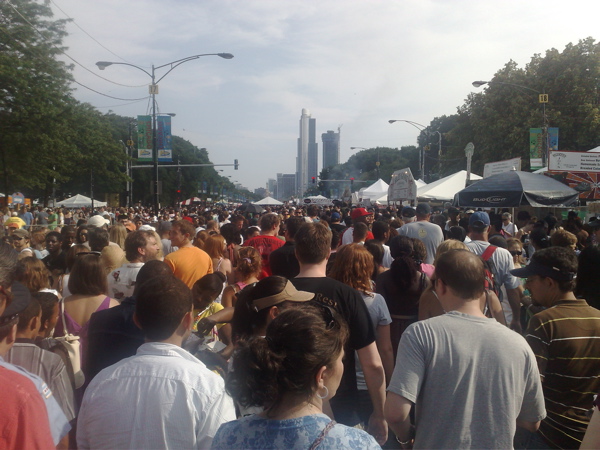
My first day on this short Route 66 trip was full of challenges. My flight from San Jose to Chicago was oversold, and there were tense moments at the airport while I waited to find out if I would be on the flight. I finally made it, but in a middle seat. I can’t remember the last time I wasn’t in an aisle seat on a flight. At Chicago, I had to spend almost an hour dealing with two separate issues with my car rental. Once those were resolved, I headed off to Grant Park, with the intention of starting my journey at the traditional beginning of Route 66 between Grant Park and Lake Michigan, at the intersection of Jackson and Lake Shore, and also pass by the symbolic beginning of Route 66, at the intersection of W. Adams and Michigan. However, when I arrived at Grant Park, the place was swarming with humanity, cars were being herded into reluctant paths by the orange vests, and roadblocks rendered GPS almost useless. I had stumbled right into Taste of Chicago, a massive food festival that has entirely taken over the Grant Park area this week.

The true beginning of Route 66 was hard to get to by car (and impossible to start the drive on, because of the closure of Jackson between Lake Shore and Michigan), so I walked to it and took a picture. It was a slow, slow crawl through the sticky ooze of summer people:

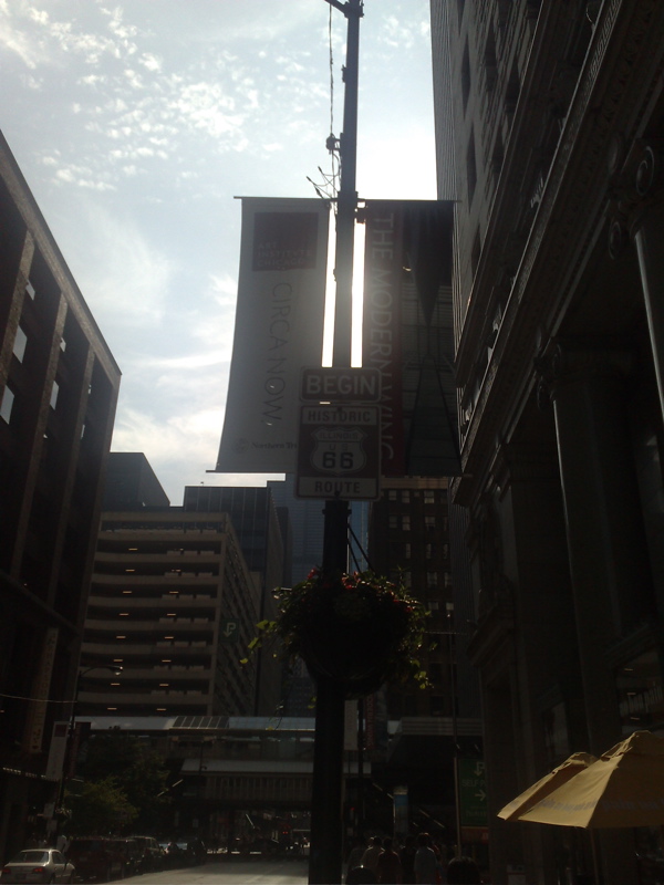
I spent what felt like ages just making it out of that mass of bodies. After a lot more time wasted on foot and in the car, navigating the obstacle course of road closures and restricted movement, I finally was able to start my Route 66 journey at its symbolic beginning:

A few minutes into my drive, I got to Lou Mitchell’s Restaurant, an establishment dating back to 1923 where it is customary for Route 66 travelers to have the first meal of their journey. Unfortunately they close at 3 pm, and I was well into my day.

I was quite grounded about the unpredictable realities of travel by now, and scaled down my ambitions for the trip. I realized I would spend an inordinate amount of time just staying on track without a navigator, so I rebalanced my freeway-Route 66 distribution to spend smaller amounts of time on Route 66 than I had initially planned. Accordingly, I took the interstate to Wilmington, a small town that Route 66 passes through, thinking I might stay there for the night. Wilmington turned out to be so small that there is no place to stay, except a very questionable motel. By the time I had decided to look for lodging elsewhere, it was dark and had started to rain. The lightning displays I witnessed on the way back north to Joliet (a larger town) were phenomenal. I had never seen such lightning discharges before. It was a hot and humid rain. On my way to Joliet, I came across the historic Launching Pad Drive-In and checked out their Gemini Giant, one of the kitschy “muffler men” that used to dot the roadside in past decades (terrible picture, I know):

I checked into a chain hotel at Joliet, with the usual amenities. I drove a substantial number of Route 66 miles between Wilmington and Joliet. In my first day’s experience, I became very aware how much I need the comforting familiarity of the interstate and its homogenized business establishments. The interstate feels like a cocoon. The purpose of this trip is to break through that cocoon as much I safely can. I felt out of my element on my first detour from the interstate, and will pursue that experience again on the remainder of this trip. However, after my short inspection of the motel in Wilmington, I have decided to retreat to a nice hotel in a large town every night. Also, I’m pretty sure my remaining posts are going to be much shorter than this! Time to enjoy the Ramada.

Will get my kicks on Route 66 starting tomorrow

My smallish, quickish Route 66 adventure starts on Jun 27 2009. I’ll be driving from Chicago, IL to Flagstaff, AZ over the course of nine days. I’ll do long hauls everyday on the interstate highways, but most of each day will be spent kicking back on Route 66. I will post updates and pictures here as often as I can go online, but at least daily, I hope. From Flagstaff, I also hope to check out Monument Valley. More on Route 66 and Monument Valley in my next post.